Saturday, June 18, 2011

Nevados Pisco and Chopicalqui

Our rest day was glorious and sunny, spent lounging and reading on the hostel’s terraces, walking around Huaraz, and eating some good meals.  While not entirely ready to go at it again (speaking for myself, at least), our time was already running short, so we headed out for a 6-day climbing excursion in the Llanganuco Valley.

We hopped on a bus with a truly amazing amount of stuff.  Michael, Matt and Juan had to work pretty hard assisting the bus guys in getting all of our stuff up and down the rickety, frail ladder to the top of the bus.  Three hours later, we were deposited on the side of the road near a burro station for climbers.

Juan, our porter/cook, with his characteristically large load.

Our first objective was Nevado Pisco, an 18,870 ft mountain.  We loaded up four burros and started the journey to Pisco Meadow Camp along a good but steep trail. The clouds were busy moving in and out, making it impossible to regulate our body temperatures.  In typical Andes fashion, the sun was set to “broil” and, when it made its appearance, it felt like we were at risk for heat stroke – only to start shivering as it ducked behind the clouds and the wind picked up. But at least there was no rain.

Nevado Pisco
We arrived at camp a little after lunch and Juan found a cave in which he set up his cooking supplies. We hung out and rested all afternoon, entertained by a particularly friendly and bold burro that we named Earl. He was more like a large, mellow dog than a pack animal.

Me with Earl, the burro
Michael and Earl the burro getting comfortable with each other
Our wake-up time was set for 1:30 a.m.  At 1:20 a.m., it started snowing.  We decided to wait an hour. At 2:30 a.m., the mountains were completely socked-in with clouds.  We decided to wait two more hours.  At 4:30 a.m., the skies were mostly clear and we decided to give it a shot.  By 5:30 a.m., when we were ready to leave, the clouds had rolled in again. We figured we´d give it a go anyway in the hope that it would clear.

Me approaching Pisco
Unfortunately, it was an absurdly long way from meadow camp to the glacier, starting with a very steep hike up the first moraine, down the other side, across the boulder-covered glacier, up a second moraine, and finally following a rock-covered ridge to the glacier. At the top of the first moraine, Kelsey began feeling sick and was still exhausted from our Vallunaraju climb. Since the weather looked bleak, we encouraged her to return to camp and rest.  Heeding our encouragements, she bade us farewell, returned to camp, passed out for three hours, and enjoyed a day of reading and awkward conversation with Juan.

Working our way up the rocky ridge on the way to Pisco!
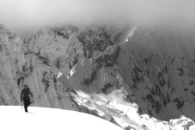
Michael, Matt and I slowly worked our way through the moraine, hoping that the longer we waited to ascend the mountain the more chance we had of good views.  We waited by the moraine lake, then we waited by the glacier, then we waited at the col… always watching the skies for signs of clearing.  Many other teams climbing that day followed the old traditional climbing rule of thumb and left early in the morning, despite the clouds and bad weather.  Each passed us on their descent, all complaining that the summit was completely socked in.  Fortunately, by late morning - just as we had hoped - the clouds slowly cleared, giving a beautiful view of the Paron Valley from the col. 

Matt and I at the col, with Huascaran Norte in the background
But by the time we made it up the mountain to the cloud line, it was mid-day and I was feeling burnt out with climbing, having had far too much time to think about it during our many long stops.  So, about 1,000 feet from the summit, I turned around despite feeling physically fine. Within 20 minutes, I looked back and the sun was shining on the summit.  I was kicking myself the rest of the way down. Michael and Matt reached the summit at the perfect time, basking in good weather and enjoying Pisco’s famously good views, the only team that day to see anything at all.

Matt, jumping for joy
Michael, near the summit of Pisco
Apparently, Michael and Matt decided not to rope up on the descent and both somehow managed to slip down a steep section and come close to falling head-first into the only legitimately-dangerous crevasse, one right after the other. They were laughing and teasing each other about it when they returned to camp, and I still haven’t the faintest idea how much danger they were actually in.  Michael assures me not much.

Matt, taking in the views on the descent of Pisco
We kicked around the idea of the guys attempting Huandoy Norte, a difficult 21,000 ft peak which loomed over our camp, and the girls going for a backpack to an astoundingly-beautiful, gem-like lake called Laguna 69.  But, in the end, we decided to stick together and attempt Chopicalqui (“Chopi”), a beautiful peak on the other side of the valley next to the Huascarans (Peru´s highest peak) that required us to establish two successively higher camps – base camp and moraine camp - before making a summit bid.

Nighttime clouds swirling around Huascaran Sur
My heart was set on seeing Laguna 69 and I was on the fence about attempting Chopi given how burnt out I had felt on Pisco, so I decided to hike to the lake by myself while the others made their way over to Chopi base camp, and meet them at camp late in the afternoon.  My plan was to traverse across a large mountainside, drop down to the lake, then follow the well-established trail down the main valley to the road, where I would hitchhike the several kilometers to Chopi’s base camp.  Everything went mostly according to plan. I had the gorgeous lake to myself for lunch before the day-hikers arrived and made good time getting all the way back down and across the valley. When I finally reached the road, traffic was non-existent, so I hiked up the road to the Chopi base camp (a collectivo showed up as soon as I reached my destination, of course), arriving by about 4pm. 

Meanwhile, Matt had been hit hard by what he dubbed “HASH” – High Altitude SHits. He looked absolutely terrible and completely drained of energy.  Instead of returning to Huaraz, he pushed through the sickness and, slowly but surely, made his way to Chopi base camp. He barely emerged and ate almost nothing all that day and night. However, by the next morning, after some antibiotics and about 17 hours of sleep, he had a miraculous recovery. His face had color again, his energy returned, and he was ready to head up to Chopi moraine camp.

Matt, recovered from HASH, but well on his way to becoming the missing link between humans and the Yeti
While I was feeling drained from my hike to the lake, I decided that I wanted to finish our climbing trip strong and go for Chopi’s summit as well.  So I joined the others in dragging my feet up the 2,000 feet to moraine camp, an assortment of flat tent spots among boulders that are protected from the near-constant and thunderous ice and rock fall from the flanks of Chopi and the Huascarans. 

Moraine Camp, with Chopicalqui looming overhead
Chopi´s lofty summit sits at roughly 20,811 feet – higher than any mountain in North America, and higher than 5 of the Seven Summits (exceeded only by Everest and Aconcagua).  From moraine camp, we had 4,500 vertical feet to climb in order to reach the summit – an ambitious amount at that altitude.  As we rested that afternoon, Kelsey started feeling the effects of HASH as well and decided that it was probably best to forego a summit bid. She made the right call, as she spent most of the next day sick in the tent and couldn’t even eat dinner. Thankfully, she recovered by the next morning for the hike and drive back to Huaraz.

Early in the morning, with the moon setting between the Huascarans
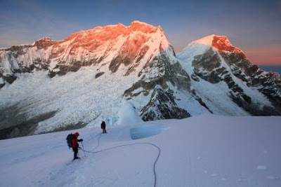
So, Michael, Matt and I woke up at 1 a.m., all a little doubtful about whether we would make the summit – especially given how tired we were from our previous climbs - but wanting to give it our best effort.  The climb was absolutely BEAUTIFUL. The skies were clear with a full moon slowly setting between the massive summits of Huascaran Sur and Huascaran Norte. We steadily made our way up and up and up, below a massive rock band and over the rolling glacier past Chopi´s highest camp (a stay at which we decided to forego). We then gained the Southwest Ridge, witnessed an incredible sunrise, and worked our way up very steep slopes (luckily we had brought two ice axes each!) and around crevasses to the summit.   

Sunrise on Chopi´s Southwest Ridge

Chopi´s summit ridge
Near the summit, each step took a great amount of energy and queasiness was felt by all. Suffice to say, roughly 21,000 feet is REALLY high. In 7.5 hours, the three of us had pushed through the exhaustion and effects of altitude, reaching the sunny, yet cold, summit at about 10 a.m. Considering we were right around the same altitude as Everest’s Advanced Base Camp, we figured that we were three of a handful of the highest people in the world at that exact moment. Pretty exciting.

Negotiating the summit mushroom
Michael and Matt celebrating at the summit, nearly 21,000 feet high
After a short summit celebration and some pictures, we started the slow and tedious descent.
Near moraine camp, but still on the glacier, the Andes' incredible range in temperature reared its ugly head again and baked us with almost unbearable heat.  We made it safely back to moraine camp and slept all that afternoon and night.  The next day, we descended to the road and made our way back to Huaraz.  

Descending into the clouds
Working my way around an ice cliff high on the Southwest Ridge
Me downclimbing through a tricky crevasse area
After showers and a little rest, the four of us met up again for some celebratory beers and our last dinner together. Matt and Kelsey took a bus the next morning to Lima, heading home exhausted but satisfied.  Our two weeks together absolutely flew by.  It was a very amazing and successful two weeks.

Matt, Michael, Kelsey, and me
Michael and I head home in two days.  All-in-all, in the past three months, Michael summitted eight mountains over 18,000 feet and I summitted six – all technical.  That´s a lot of climbing!!  And a lot of discomfort – especially considering that we also did one six-day and two three-day backpacking trips.  We definitely experienced the Andes!!   “Amazing” is the only word that describes our time here.  However, after 3 ½ months traveling the wilds of South America, we are ready to return.  We miss the company of our family and friends, and the comforts of our Oceanside, Oregon home.  After experiencing so many places here in South America, we are more confident than ever in our belief that Oregon (particularly the coast!) is one of the finest places to live in the world.  We both look forward to our next stage of life together, as attorneys at Albright Kittell, with many travels and adventures left ahead of us.  

Just an FYI - Michael is making a video of our time climbing in the Cordillera Blanca which he is really excited about, so be on the lookout for that in the next couple months!!!

The Quilcayhuanca Valley and Climbing Nevado Vallunaraju

A quick bit of background: Matt Ellis is one of Michael’s best friends and his (and our) frequent climbing partner. He and Michael have been climbing together since they both discovered the sport at a YMCA camp over 10 years ago. Matt is now an engineer in the Seattle area and dating Kelsey McFarland, a physical therapist who has set her sights on learning to climb and was willing to jump off the deep end by learning the techniques on Mt. Rainier (her summit attempts were foiled by bad weather) and then heading straight into the Andes, the second-highest mountain range in the world.

When Michael and I were planning this last leg of our trip, Michael urged Matt and Kelsey to get as much time off as possible to come down to join us. They timed it perfectly to be here for the last two weeks of our trip, and I tip my hat to them both for working so hard to prepare, mentally and physically, for the inevitably exhausting two weeks of climbing peaks in the 18-21,000-ft range. They both showed up fit and ready, opening up our climbing possibilities.

Kelsey, sporting her usual smile
We didn´t waste any time getting started. After one day of logistics, shopping and organizing gear, the four of us were off for a 3-day acclimatizing (for Matt and Kelsey) backpack up the Quilcayhuanca Valley, aided by our cook, Juan (who would be with us for the whole two weeks), and burros carrying our gear.

Our camp in the Quilcayhuanca Valley
The hike in wove through a beautiful meadow - which is also used as a community cow pasture - with increasingly beautiful views of the surrounding mountains as we made our way deeper into the valley. We arrived before sunset, set up camp among a field of purple wildflowers, and sat down to popcorn and one of Juan’s now-famous three-course meals.

The moraine lake above the Quilcayhuanca Valley
The next day, we set out on our acclimatizing hike to a moraine lake and a mountain pass. This plan was more ambitious than we first thought. It started with a gradual ascent up a rocky valley, followed by steep switchbacks up to the lake. That took us until lunch. We then made our way to the pass by hiking cross-country on a rising traverse over grasses and loose rock, up and down the rolling flanks of a mountain. Eventually, we reached our destination and the highest point Matt and Kelsey had ever been (at that time) of around 16,800 feet, with outstanding views of both the Quilcayhuanca and Cojup Valleys, with dozens of peaks visible from this almost 360-degree view.

Michael and I at the pass with the Quilcayhuanca Valley in the background
Tired, but feeling pretty good, we made our way back to the comforts of Juan’s cooking tent. The next morning we hiked out, all with slightly blistered feet, and made our way back to Huaraz where we showered, re-packed, and prepared to leave the next day for our first climb.
Sunset from our camp in the Quilcayhuanca Valley
We chose Vallunaraju as our first mountain to climb together. Vallunaraju stands at 18,650 feet and is located just north of Huaraz – always visible from our hostel’s terraces. The glacier route is a popular climb, meaning there is often a visible trail weaving past crevasses all the way to the top. While summiting any 18,000 ft glaciated mountain is a demanding proposition, Vallunaraju is not very technically difficult or committing – should anyone need to turn around because of altitude sickness, they could do so fairly safely.

Vallunaraju at sunset (the summit is on the left)
While the mountain seemed so close, the road was incredibly terrible: it took about four hours of inching along in our taxi to get to the trailhead. We also ran into a snag in the form of an uptight, young and rule-bound National Park officer who was hell-bent on turning our taxi around because we didn’t have a paid guide or a permit from the government allowing us to climb without one. We had heard that this rule was officially on the books, but had been climbing in the National Park for over two weeks by ourselves without being bothered by it. Fortunately, luck was on our side. A car pulled up behind us with a climbing guide with whom Michael had previously shared route conditions of Ranrapalca and Shaqsha. So, kindly, the guide stepped in to vouch for our climbing abilities and, when the officer still wouldn’t budge, called his buddy at the National Park office in Huaraz who pulled rank on Mr. Uptight and gave us special clearance for that climb. We drove away very grateful – that could have really put a damper on the trip.

The approach to camp at the base of the mountain was brutally steep. I was so thankful that Kelsey was there so we could give each other encouragement as we fought the slippery rocks and dirt up the path. At a smooth rock slab, we found that the men had graciously set up a fixed rope so that we could safely haul ourselves up that part. I’m not sure I would have made it otherwise – at least it would not have been pretty.

Matt, Kelsey and I hangingout in our down jackets at camp with Juan making snacks in the background.
Finally, we made it to our high camp at roughly 15,800 feet, had dinner and quickly went to sleep.  Our alarms went off at 1:30 am and we crawled out of our tents for a breakfast of champions: peanut butter and jelly on stale bread with NesCafe instant coffee. It was painful, but the best power food we had.  Soon, we set off and began the hard work of climbing slabs of rock in plastic boots and heavy packs in the dark, the only obstacle between us and reaching the glacier.

Our camp below Vallunaraju
About half an hour into it, and after a particularly strenuous move, Kelsey’s breakfast decided it was done and she threw it up right there on the rocks. We weren’t sure if she could continue, but she said she felt better and no other factors pointed to a dangerous altitude-induced disease, so she carried on! We made it to the base of the glacier soon after, roped up, and went forward. The moon set early, leaving us with a dark, starry night for the next several hours as we marched our way up the slopes towards the summit. It was cold!!

The view at sunrise while climbing Vallunaraju
The incline dramatically increased as we neared the summit. Around 18,000 feet, both Kelsey and Matt started to really feel the altitude but pushed forward - Kelsey was especially hampered by the lack of food in her system. But, after some short rests, she kept enduring and never gave up. Michael and I were very impressed with her strength and willpower, and we were all ecstatic when she took those final steps to the summit, her first summit ever. That her very first summit was in the Cordillera Blanca at near 19,000 feet should give her bragging rights for a long time to come. Simply amazing.
Descending Vallunaraju after Kelsey's first summit!
We happily made our way back down to camp where we had some food and a short rest before heading back to the road via a slightly less painful trail than we had taken up. We endured the endless ride back to Huaraz, looking forward to a rest day (ultimately, the only one of our entire trip!).

Matt and Michael on the summit of Vallunaraju

Saturday, June 4, 2011

Huaraz, Peru

After reading some of our recent blogs, some of you may be asking "Why on earth do you climb?" Sitting in Huaraz is a perfect place to ponder that question. As far as the tourism industry goes, this is a city made for climbers. Yes, there's trekking, day-hiking, and mountain biking, perhaps even a store or two, but the reason people come here from all around the world is to climb... and the city has catered to that call.  The main reason, of course, is it's proximity to the Cordillera Blanca, a mountain range so high and vast that guidebooks only name the highest and most popular peaks - there aren't enough pages (or long enough attention spans) to name every glacier-covered, snow-capped peak.

Sunset over Huaraz, from our hotel
Capitalizing on this asset, the streets of Huaraz are littered with guideshops and gear-rental shops, with more opening every day as the height of the climbing season draws near. Sun-burnt and disheveled tourists with backpacks and dark glasses wander the streets and occupy the restaurants. Pictures of mountains, action shots of climbers and maps of the mountain range decorate the walls of hostals, restaurants and shops.  The town is alive with excitement, adventure, and opportunity.  Michael and I feel very at home here.

The day we arrived, we had a stroke of luck - we found the La Casa de Zarela, our hotel for our time here in Huaraz. Not only do we have the comfort of routinely coming back to the same room (the closest thing we have had to a home in 3 months), we also have access to a full kitchen and tiers of open-air patios for eating, relaxing, and drying out wet gear. Zarela, the owner, has been nothing short of an angel. She is extremely connected and has acted as our agent throughout our time here by translating and organizing all of our taxis, burros, cooks and porters. On top of that, she is an extremely cool person. I don't know how we would manage without her.

Zarela's casa is a hub of climbing activity with all sorts of folks of different nationalities coming in with various plans and ambitions. Michael and I are certainly not the craziest or the most ambitious. The climbing community here reaches a whole new level. After our intense climb of Ranrapalca, we went to our favorite pizza joint (as pizza and beer cure most climbing ailments) and our now-familiar waiter asked us how it went. We told him the story and showed him some videos we were particularly proud of. He watched, blinked, and then said "So, what's next?" What's next!!?? Isn't that kind of a big deal!? We could have said to him "We climbed the North face of Ranrapalca and, oh, did you see that the stop light is out on main street?" Apparently these kinds of stories are part of casual conversation here! In the States we might at least get some bragging rights, but, here in Huaraz, we are in the middle of the pack.

So, again, this begs the question - why do we climb? Clearly this is not just some random hobby Michael and I have latched on to. While I can't answer the question for anyone else as climbers’ motivations are as diverse and any set of individuals, I can at least speak for myself.

I climb because it takes me to some of the most magical, beautiful and surreal places on the planet that most people never get to experience. To be walking on snow alone in the wee morning hours with the stars and moon above you, witnessing the first rays of the sun peeping over distant mountain tops, standing in awe at what nature created, is a truly spiritual experience.

Huascaran, the highest mountain in Peru, at sunset
I also climb because I like the multitude of challenges it presents. While there are moments with adrenaline rushes, it is a far cry from your typical short and intense sky-dive or bungee jump. It's a slow, sometimes tedious, endurance sport more akin to running a marathon with added mental components that require focus and precision instead of zoning out. There are many forms of climbing - rock climbing, ice climbing, bouldering... the list goes on - but the type of climbing we most like to do (mountaineering) is all-encompassing: it tests you physically, mentally, emotionally and can even touch you spiritually. It can give your soul wings, but can also push the limits of your reserves. The time and effort that goes into every climb makes completing the process a reward in itself, whether or not I set foot on a summit.

Fiery clouds above Vallanaraju, a climb we later did with Matt and Kelsey
Finally, I climb because it connects me to an athletic, positive and inspirational community of people across the globe who love to challenge themselves and experience the outdoors. Meeting people in the climbing community, sharing stories, and reading about others motivates me to keep my priorities straight - to stay physically fit, to apprecaite the natural world around me, to enjoy outdoor hobbies instead of getting trapped in a corporate world, and to spend quality-time with my husband, my partner, instead of being absorbed by work, the internet or tv.

So, yes, it's dangerous at times, exhausting, uncomfortable, and gives me a list of things to complain about from blisters and chapped lips to the pain of snow-blindness, but, at the end of the day, those discomforts don't outweigh all of the things that make climbing worthwhile to me. After a few days or weeks of healing and rest, I´ll be ready to do it again.

Nevado Ranrapalca

After a day of rest, Michael and I were mostly healed and feeling ready to take on another challenge: the North Face of Ranrapalca. Nevado Ranrapalca stands over 20,000 feet tall at the end of the Ishinca Valley, dwarfing Nevado Ishinca, our first climb about 2 weeks before.  It is a difficult climb - certainly the most technical we´ve attempted together.

The imposing North Face of Ranrapalca
While notoriously "scary-looking," this route caught our attention for several reasons: the face is a beautiful, kilometer-high wall of rock, ice and snow with two distinct, horizontal rock bands. It's a committing route with great exposure (and great views!) that may only exist through this season due to the rapidly-changing climate. In fact, this is the first time in about five years that it has been climb-able as a snow route and the chance may simply never come again.  In addition, the descent was via the Northeast face of the mountain - a steep rock and snow headwall towering above a heavily-crevassed glacier - giving us a full tour of Ranrapalca in all its glory.  Also, we felt acclimatized and in shape, and wanted to try something hard.  The climb, which requires 7,500 vertical feet from start to finish, normally takes 4 days, but we figured we could move fast and do it in 2.5 days in order to be back in Huaraz when our friends, Matt and Kelsey, planned to arrive.

Our ascent is in red and our descent is in black
We hired a particularly fiesty burro to carry our packs to just below Ranrapalca.  From there, we carried our packs up a steep, rocky morraine where we set up camp just in time to enjoy a beautiful sunset.
 
A beautiful sunset from our Ranrapalca camp
The alarm went off at 1 am and we awoke to one of the darkest nights we have ever experienced - there was no moon and even the stars seemed dim. Completely dependent on our headlamps, we made our way through crappy rock and up the rest of the morraine to a steep snow slope at the base of the face. After a long stretch of stairmaster-like steps, we hit our first crux at 3 am - an ice bridge leading to a vertical, 75-foot pitch of mixed rock and thin ice above a huge cliff.  This was completely unexpected as snow was supposed to extend all the way to the base of the face.  I was not happy. In addition to being frightening, this little section exemplified a whole new level of technical difficulty to which I have no amibition to reach - there's just a point where it's so hard it's not fun anymore, and this was it for me.

But Michael wasn't ready to give up and could see that the vast majority of the face (after this section) was manageable (albeit very steep) snow and ice. Using a combination of two technical ice axes, crampons, bare hands, and sheer force of will, Michael slowly and steadily made his way up the rock and ice to a safe anchor in the snow beyond. After a brief yelling match about whether we should turn around, he proceeding to literally haul his very reluctant wife up that section. That was the low point of the climb.  However, the next several hours were spent kicking steps and planting our ice axes, slowly but surely, up the roughly 65-75 degree snow and ice, watching an absolutely magnificant sunrise from what felt like the top of the world.

Just below the summit plateau, at around 20,000 feet, we reached the second rock band.  It was quite difficult to navigate and climb, but wasn't nearly as scary as the first - probably because we had sunlight at this point.  Michael, again, did a great job leading the pitch and I followed, with less reluctance and less assistance from the rope this time.

Taylor at the top of the North Face
Happy and tired, we were a little disappointed to look down the other side of the mountain - our descent route.  It was much longer and hairier that we expected.  Fearing the inevitable late-afternoon rockfall, we didn't dally in starting to go down.

The first part of the descent was a rock and ice face about as steep as what we had just come up. It took several pitches of exposed rappelling to get to the bottom of the face, navigating around a few crevasses along the way.  Unfortunately, at the bottom of the face where the glacier begins to slope at a more reasonable angle, there was one huge crevasse. After some scouting, we found an overhang just far enough over the opening that we could lower ourselves over the 10-foot edge and get one foot onto the other side. To be honest, this was really exciting to do and I'm sure I wore a silly grin on my way down, hidden behind my neckwarmer.

Taylor, thankful for good weather on the descent
Once past this hurdle, we were able to actually walk (finally!), a much faster means of getting down. I led our way through the crevasse field, avoiding the exposed cliffs and trying to find the safest and easiest route back to camp. While it took a long time, with some unfortunate back-tracking, we made it down, enjoying stunning views and perfect weather, arriving at camp a little before sunset.

A photo taken on our descent
Our descent wasn't over - we still had to pack up camp and descend 2,000 feet to the refugio in the valley where we had left our extra supplies and planned to sleep in actual beds with mattresses. As we slung our full packs onto our backs,  we wished we could have arranged burros for this leg of the climb too.

We thought we were out of the danger zone, but only a few minutes into our descent down the dusty and slippery morraine, my biggest fear came true: Michael fell. I watched from about 10 feet behind, screaming in horror, as his plastic boot somehow faltered on a rocky step and the weight of his heavy pack pulled him off-balance, sending him cascading backwards over a small shelf, where his poles stayed put, and then over a 20-foot cliff, finally coming to rest after another small shelf. It was like watching an action movie in slow motion. He came to a stop sitting upright, stunned.  Unbelievably (and reminiscent of his bike accident last spring), he came out of the whole incident with only a few scrapes on his hands and a small tear in his jacket. That man is blessed. And so am I, because we were about 8 hours round-trip from any help whatsoever and it was quickly getting dark. It's truly a miracle that Michael got up and walked out to the refugio, carrying his pack the whole way.
The cliffs Michael fell over
The rest of the way down was painful with the little agonies of cuts, bruises, blisters and burned-out muscles, but was otherwise without incident. We both crashed hard at the refugio after a little warm food, never before appreciating the comfort of old, used and smelly mattresses quite so much.

We met the burro driver the next morning and made our way out of the valley and back to Huaraz, sore and still tired but feeling very proud of ourselves for having completed our most challenging climb yet. Most of all, we were ready for several rest days in Huaraz and perhaps a nice, gentle backpack when our friends, Matt and Kelsey, arrived.

Nevado Shaqsha

After our trip to the Ishinca Valley didn´t go as well as we had hoped, we decided to do a relatively straightforward and short confidence-building climb of Yannapacha (roughly 18,000 ft). We caught a 6:30 am collectivo from Huaraz up the Llanganuco Valley, the most "V"- shaped valley I've seen yet with an amazing road cut into the cliff, guarded by 20,000 ft peaks. Four hours of switchbacks later, we were dropped off on the side of the road at "the curve past kilometer 48," as instructed by our climbing guidebook.

We were alone this time - no porter, cook or burros - since the approach was supposed to be short without much elevation gain. Soon after we started hiking, dark skies descended and began peppering us with rain. Two hours later, we reached moraine camp - an ugly, cold, viewless and seemingly-spiritless set of flat spots on rocks. The rain was coming down hard, the wind had picked up, and it was freezing. We decided life is just too short for that much unpleasantness and turned around. We walked all the way back to the road and hitch-hiked a ride to Huaraz.

Dark clouds and rays of light
Unfortunately, about when we caught our ride, the skies started to clear. We watched with growing regret as the bad weather retreated and an unimaginably beautiful sunset took over the sky. Michael was devastated. For him, it was the worst day of our entire South America trip. I felt frustrated and foiled, but a bit more apathetic. We both were much in need of an enjoyable adventure.

After careful thought, we picked Shaqsha, a picturesque two-summit mountain reaching about 18,800 feet. We were the first team to attempt Shaqsha this year. We hired burros to carry our packs for the 5-hour, 4,200-ft-elevation-gain approach to base camp on the moraine below the glacier, a beautiful and sheltered camp on soft sand, surrounded by rocks. Unfortunately, we arrived in driving snow and cold temperatures… but we took note from our Yannapacha mistake and stuck it out. Soon, the weather cleared considerably.

Afterglow on Shaqsha, from near our camp
The next morning we opted for a late start time of 5:30 am. Clouds still shrouded the mountain, but didn´t threaten a storm. We had two choices for our route: the South summit route is a short and direct climb up sustained 70-80 degree snow and ice; the North summit (the main summit) route climbed cleanly and directly through a huge, cascading glacier with sustained 60-70 degree snow and ice. We opted for the North summit and picked our way across the glacier.

Our route on Shaqsha, directly up the West Face
The next several hours were both exciting and grueling, as we pushed our way up steep soft snow. I don't usually feel this way, but that day I loved my thighs. Climbing the snow up Shaqsha's face was like exercising on a stairmaster for five hours straight.

The clouds hung around all morning – always shifting - but the wind and snow stayed away. We felt like we were in some other-worldly, magical place. Fortunately, the clouds blocked any view down the incredibly steep and exposed face we were climbing up, which helped me stay focused instead of freaking out. The few times I did look down through a break in the clouds, I had to audibly tell myself "OK, keep climbing. Stay focused. Don't think about it."

Taylor, high on the West Face
Near the top, we discovered a small but problematic summit cornice (an overhanging section of snow that forms at the top of a ridge or peak due to consistent wind). It took us probably an hour of traversing hard-to-protect 80 degree snow and ice slopes to get around this last 5 meters to the summit (including an awkward and scary crawl on a little ice shelf under the cornice). Frustrating! But, the summit was worth it: a very thin knife-edged ridge of ice and snow just wide enough to straddle, looking down endless depths on either side. I promptly sat down, dug my feet into the snow, and told myself not to look down. I don't think I've ever been on a more exposed summit. We didn't stay long.

The knife-edge summit of Shaqsha
The descent was almost as difficult as the ascent, and even more technical. We had to descend in protected pitches: First, Michael would set up an anchor in the snow to hold him into the mountain, then rappel me down the length of the rope. Next, I would set up and anchor and Michael would down-climb to me. Rinse and repeat until we were off the face of the mountain, about 3 hours later, very tired.

Overall, Michael and I had a really amazing time, kept in good spirits the entire day, and enjoyed the technical challenges Shaqsha presented to us. Just as we got down to the crevasse field, the sun came out and we could look back and gawk at our route. We happily made our way back to camp to relax for the remainder of the day.

Walking back to camp - beautiful!
Problems soon arose. Because our climb was mostly in the clouds and our attention was fully captivated (and necessarily so) by the technical difficulty and beauty of the route, Michael and I each broke a cardinal rule of climbing: I didn't wear sunglasses and Michael didn't put on sunscreen for most of the morning. The price of this mistake was high, and we both paid dearly. Michael's already-present tan lines reached a new level and his lips eventually blistered and turned partially black. I spent the next 24 hours in utter agony. I had no idea that snow-blindness was so painful. It felt like someone was torturing me by rubbing sand in my eyes, which were so swollen and heavy that I could barely lift my lids for more than a few seconds. Between that and a muscle spasm in my back, I only made it through the night thanks for our emergency stash of Vicodin.

When we met our mule driver the next day, he could clearly see that I was having difficulty walking at any acceptable pace and offered to let me ride the mule. Damn my pride, I rode that mule with my eyes closed and my feet hanging barely off the ground the entire three hour descent to the road. From there, we took a collectivo to Huaraz where I spent the rest of the day lying in the dark and listening to 3-month-old episodes of "Wait, Wait, Don´t Tell Me" and feeling like an complete idiot for inflicting such preventable suffering on myself. Amazingly, by the next morning, my eyes were almost back to normal. We promptly went out and purchased the darkest sunglasses we could find blue wrap-arounds with an electric orange reflection off the lenses that make me feel like a 12-year-old boy. Michael thinks they are awesome. I don´t, but I'll wear anything that prevents agony like that from happening again.

Michael leading through deep snow at the base of the West Face
Despite the painful aftermath, this climb of Shaqsha will go down in our memories as one of our all-time favorites and a much-need enjoyable adventure to lift our spirits and keep us excited about our other climbing prospects here in the Cordillera Blanca.
Sunset on Shaqsha